|
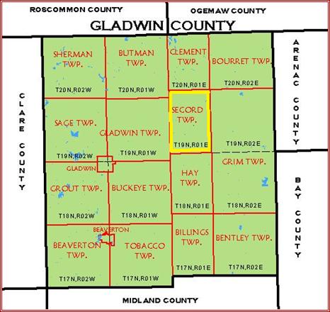
Regional Location
Secord Township comprises an area of 23.4 square miles, of
which 22.5 square miles is land and 0.9 square miles is water.
The Township and Range numbers for
Secord Township are T. 19 N .- R. 1 E. – Coordinates 44°2’34”N,
84°20’17”W.
Secord Township is located west of I-75 in Gladwin County.
The township is bounded by Clement Township to the north, Grim Township
to the east, Gladwin Township to the west and Hay Township to the South.
Historical records reflect that Gladwin County was organized in 1875 and
Secord Township, while originally visited and settled in 1861 by Canadian Marvel
Secord, was officially recognized in 1912.
Secord Township has a population of 1,151 residents per the 2010 Census.
Figure 4.1
Location Map of Gladwin County

Figure 4.2
Location Map of Secord Township
Secord Township is located in the northeast section of
Gladwin County. It is a township
known for its natural resource and recreational attributes including the
Tittabawassee State Forest. The
Tittabawassee State Forest has 80,000 acres of state land in Gladwin County and
covers almost a fourth of the county on the east, and offers opportunity for
hiking, hunting and snowmobiling.
There are nearly 50 miles of backwater ponds, 450 miles of waterways and 7300
acres of lakes and ponds in the county.
The Tittabawassee River runs the length of the county and provides two
major impoundment lakes, Secord and Smallwood. This
waterway is of major significance to nearly every aspect of Secord Township’s
quality of life
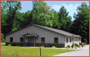
Figure 4.3
Secord Township Hall
History
Prior to the arrival of Europeans, Secord Township, along
with other townships throughout Gladwin County, was originally inhabited by
Native American tribes most specifically the Ojibway (Chippewa); however Sauk
and Menominee Tribal presence has also been noted.
The abundance of wildlife in the area provided a way of life and means of
living to the Native American populations.
This same abundance of wildlife served as an attractant to
other adventurers including the first white settler - a Canadian named Marcel
Secord.
Mr. Secord first arrived in 1861 while canoeing the Tittabawassee with
his family. In 1864 he built a log
house nine (9) miles from Gladwin known as Dick’s Fork (named for a Mr. Dixon).
Mr. Secord was a hunter/trapper and provided meals and lodging to early
lumbermen to the area. This area would
later come to be known as Secord with a rural post office being established in
1912.
Research is
underway to determine the importance of an ancient trail that was noted by the
crew of the 1839 re-survey of Township 17 north Range 2 west, which later became
Beaverton Township. The eastern terminus
of the "Muskegon River Trail" was plotted at the confluence of the three
branches of the Tobacco (Assa-mo-quoi-Sepe) River in the northwest corner of
Section 12. It is possible that an early
cross-country route from Saginaw Bay to Lake Michigan proceeded up the Saginaw,
Tittabawassee and Tobacco Rivers to approximately the point west across Ross
Lake from the Beaverton City Cemetery.
At that point the canoes would be portaged along the trail to the
Muskegon River, and then floated down to Lake Michigan.
Geography, Topography and Soils
Secord Township consists of a total land area of 23.4
square miles or 14,442 acres. It is
located in Gladwin County which is a largely rural forested area near the center
of Michigan’s Lower Peninsula.
All of the soils and topographic features within Gladwin
County and Secord Township are the direct result of various glaciers that
covered Michigan at various times.
The most characteristic features resulting from the glacial activity are various
moraines, lakes, tills and outwash plains.
Agriculture activity is influenced considerably by the type of terrain.
The township
remains relatively undeveloped with the majority of development consisting of
single-family residential. This use
is most concentrated along the Secord Lake Impoundment, which runs north and
south through the Township. The
remaining single-family homes are distributed throughout the township.
It is likely that many of the residences along the Secord Lake
impoundment are seasonal in nature.
Others have become year-round homes as people have retired and moved into these
home permanently.
This is little
commercial development within the township itself.
What exists is primarily associated with Secord Lake and other
recreational uses; hunting/fishing/boating, camping, etc. and consists of
campgrounds, canoe rental and party stores.
The City of Gladwin provides a commercial center to the west, as well as
the city of West Branch to the north.
Many residents of
Gladwin County commute to outlying areas for employment.
Within the county, employment is reliant on retail trade, government,
health services and the manufacture of plastics.
Large areas of Secord Township are part of the Au Sable State Forest,
which covers approximately 6,029 acres.
Of this, the state of Michigan owns an estimated 1,320 acres.
All of Secord Township is within the Tittabawassee River Basin.
The State of Michigan owns approximately 5249 acres of forested land in
Secord Township.
Soils
Gladwin County,
as a whole, consists of materials from the upper and lower Mississippian series
of the Paleozoic era. Various strata
contain minerals of varied importance. In
addition to the oil and natural gas, which has formed in porous rock or pockets
between strata, economic deposits of limestone, gypsum, salt & brine were found.
Most of the
topographic features throughout Gladwin County, including Secord Township, are a
result of erosion or deposition during the Wisconsin Glaciations, the last
glacial period. The part of the glacier
that covered Michigan began to recede about 14,000 years ago and moved
completely out about 8,000 years ago. The
glacial drift (deposit) that was left as the glaciers melted covered the entire
County to a depth of several hundred feet. It
formed such topographic features as moraines, till plains, outwash plains, lake
plains and glacial drain ways.
Secord Township, along with all of Gladwin County, is part
of what is known as the Saginaw Formation.
It consists of predominately Pennsylvanian (or sandstone) soils with a
secondary soil presence of Shale.
The composition
and behavior of soils are extremely important to nearly every aspect of
development. Stability, permeability, slope, depth, drainage, chemistry,
fertility, and wetness, among others, all bear on the suitability of land for
particular uses. Knowledge of soils is
elemental to environmentally sound growth. The
soils in Secord Township are generally poorly drained and sandy in nature.
Wet and sandy conditions are favorable
for forested areas.
Wetlands can limit development in a specific area and each
type and extent must be examined before proceeding with any development project.
The U. S Soil Conservation
Service has conducted soil surveys of Gladwin County.
This investigation classified the soil types within the Township are
generally of the Iosco-Brevort and Allendale-Pickford-Pinconning Association.
A review of these
soil types reveal that they only offer moderate limitations for picnic,
playground and trail development. It
is important, however, for Secord Township to recognize and be aware of the
policies that are intended to protect these natural features.
Secord Township
Center: 44.0153°N 84.3478°W
Elevation at center: 728 feet (222 meters)
Quad: Secord Lake
Drg Source Scale: 1:24,000
Projection: NAD83/WGS84
Figure 4.4 Topographic
Map of Secord
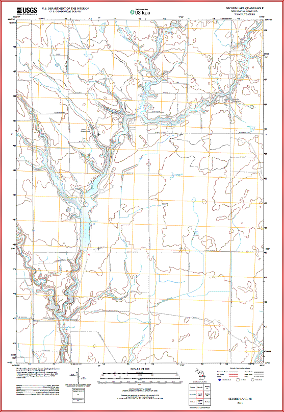
Source-
USGS
2011Secord Lake 1:24,000 quadrangle map from http://www.topoquest.com
Figure 4.5
Soil Data Map of Secord
(To be added at later.)
Climate
The Township
enjoys a relatively mild continental climate which is moderated by the proximity
to the Great Lakes. Temperatures
are generally warmer in winter and cooler in summer than area those of areas of
similar latitude in the western part of the state.
The average daily maximum temperature in July is 82 degrees F.
Average precipitation stands at an estimated 30 inches per year with most
occurring between April and September.
Snowfall averages slightly less than 44 inches per year but is subject to
wide variations from year to year.
Prevailing winds are generally from the southwest and are strongest in March.
Hydrology
Throughout the County and the township, there is a well-defined system of rivers
and streams draining from the north and west generally towards the south and
east. All of the County and the
Township lies within the Tittabawassee River Basin.
Other significant rivers include the Molasses, Tobacco, Cedar and the
Sugar. Many river basins are deep
and dam fills have been installed at Edenville, Smallwood, Secord, Beaverton and
Chappel. The dams have created
sizeable lakes around which both summer and year round residences have
developed. There are over 470
linear miles of rivers and streams in the county with just over 2% of the
county’s area being surface water.
This presents unusual recreational opportunities for both year-round and
seasonal residents. Campgrounds and
canoe rentals owned by private developers occupy portions of river frontage.
The
forest and water resources in Secord Township provide excellent opportunities
for outdoor recreation which includes tourism.
Specific facilities relating to these recreation forms, such as
campgrounds and water access sites, will be discussed in detail in the
Recreation Inventory of this Plan.
Mr. Secord’s name has been shown
as both Marcel and Marvel in historical records
|