|
|
| Secord Township Masterplan |
|
|
Good planning is critical to the future quality of life in Secord Township.
The final critical step in completing a
Master Plan is to determine the types, location and intensities of development
that will occur over the next twenty years. With
the establishment of a Future Land Use Plan, Secord Township intends to ensure
that existing land uses can continue; that natural resources such as water,
wetlands, forestlands and farmlands will be protected; and that reasonable
growth can be accommodated with minimal land use conflicts or negative
environmental impacts. While future land
uses are difficult to predict, a future land use plan provides a scenario which
Secord Township may use as a guide when considering land use and development
decisions. The Township Planning Commission, with public input and assistance from EMCOG, developed future land use recommendations for Secord Township. Future land use recommendations are based on environmental conditions, existing land uses, available community services and facilities, existing patterns of land divisions, current zoning (found in Figure 7-1) and community goals and objectives. The preservation of the existing character of Secord Township played a significant role in creating the final future land use map. The Future Land Use Map reflects this preservation goal by showing a strong correlation between existing land use and future land use while at the same time designating generalized areas for mixed-use commercial development in order to prevent these uses from occurring in areas of incompatible land use. Land Use Planning Areas Listed below are five different land use planning areas. These areas are the current Zoning Districts in Secord Township. This section will provide explanations of each land use planning area, including purpose, recommended development density and, compatible uses. • Recreational Residential R-1 • Mix Use Residential R-2 • Commercial C-1 • Mixed Use Commercial C-2 • Agricultural/Recreational A-1 Some lots created prior to this Master Plan and the Secord Township Zoning Ordinance may be smaller than the larger lots this plan recommends. Future development regulations should recognize these conditions and provide for the reasonable continuance of their use and character.
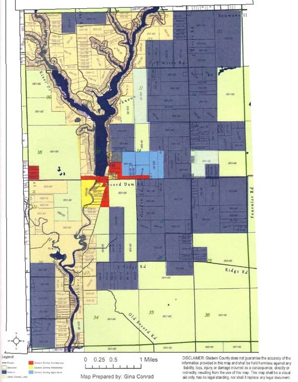
Figure 7-1.
Current
Zoning District Map
--
this map will be revised Recreational
Residential The Recreational Residential development category is primarily designed to accommodate single-family dwellings on lots with a minimum size of 12,000 square feet (a little over one-quarter of an acre). The recreational residential category is intended to preserve existing resort-like residential development mainly along the shoreline of Secord Lake, where land has already been subdivided into smaller lots. Principal uses would include single family dwellings. Special uses may be allowed if they are designed to be compatible with the residential setting. The Zoning Ordinance lists all the possible uses in detail with regulations in Articles 4 & 5. The township requires site plan review and special approval for all uses other than individual single family homes. This land use is mainly waterfront residential; it would address issues relating to water quality and shoreline protection. Renovation and redevelopment of existing streamside properties is expected to continue as seasonal residences are replaced by year round homes. This renovation and redevelopment should be sensitive to the protection of native vegetation greenbelts. Higher density residential uses, such as apartments, townhouses, condominiums, convalescent or nursing homes and manufactured home developments should be restricted due to a lack of public water and sewer service available in Secord Township. If adequately engineered wastewater disposal systems are included as part of the design, higher density development can be considered. It is also important to note that under state law, manufactured homes are allowed in any residential area if the structure meets all requirements set for site-built homes. Mixed Use Residential
Secord Township has made it a high priority to continue the farming tradition and maintain the rural character of the community. Farmland/Forested land not only contributes significantly to the scenic and rural character of the township, but also represents a way of life that the character of the community is built upon. The Mixed Use Residential land use designation is the second most extensive land use category in the township and is intended to encourage the continued existence and expansion of large parcel lots in the township. The plan recommends this category accommodate single family and two family dwellings at a low density. All the uses allowed in Recreational Residential will also be allowed in this land use. Plant nurseries, schools, government administrative buildings and fraternal organizations, greenhouses, bed and breakfast inns, churches, and forest and wildlife preserves are also allowed. Special uses may be allowed if they are designed to be compatible with the primary uses. The Zoning Ordinance lists all the possible uses in detail with regulations in Articles 4 & 5. The township will require site plan review and special approval for all uses other than individual single family and two family homes. Where compatible with surrounding uses, private clubs, veterinary services, certain commercial establishments relating to agriculture, human care facilities, manufactured home developments, golf courses, publicly owned buildings, bed and breakfast facilities; home occupations contained within the dwelling; private garage and carports; storage yards; warehousing of inoperable mechanical equipment; yard sales and publicly owned parks would be allowed with an approved site plan under the special approval process. Current land use patterns in Secord Township result in a large portion of the township being forested. The presence of this landscape is a major factor resulting in the community character and quality of life that Secord Township residents enjoy. The township has placed a high priority on maintaining quality natural resources and the current “character” of the community. This category encourages forestry operations, resource management, wild land recreation activities, and farming operations combined with residential uses. Larger residential lots of 1 acre (43,560 sq. ft.) provide privacy and tend to maintain ecological integrity of the natural resources. Other uses recommended for these areas include, parks and playgrounds. Under the special approval process in the township’s zoning ordinance, recreational or hunting camps and clubs and golf courses and could be allowed with site plan approval by the Township Planning Commission. Commercial Secord Township is mainly a resort community with the majority of its population as retired couples. Hence the community has aging demographics. In its plan to attract younger populations the Township is making this new land use available for all kinds of activities that can make it attractive for small- scale recreation type businesses and high-density residential developments to happen. It will be close to the Lake, but still will be at a distance so that it does not disturb the existing residents and the resort character that is most valued by its residents. These areas will be designed to serve both local needs and motorists passing through Secord Township. Highway commercial businesses, which are heavier traffic generators, are located to serve vehicular traffic. Development should consider access management, buffering, parking, signs and landscaping to maintain traffic safety and minimize any negative visual impacts of development along the main roads. Compatible uses include gas stations, vehicle service and repair businesses, auto sales and service, retail operations that require large outside storage areas, public buildings, apartment complexes, drive-in food and drink establishments, hotels and motels. As these commercial centers develop, they could expand out farther, as needed. Mixed Use Commercial Much of the major retail and service needs of the township are met by facilities in the Cities of Gladwin and West Branch, however Secord Township wishes to set aside areas to accommodate neighborhood business services that will meet the immediate needs of residents. Uses that would be allowed in Mixed Use Commercial areas would include retail and service stores without outside storage areas, professional offices, banks, public buildings and fraternal organizations. The Mixed Use Commercial land use category is designed to provide sites for wholesale activities, warehouses, retail operations that require large outside storage areas, light manufacturing operations. In order to accommodate future growth and possible commercial/industrial development on the M-30 corridor, the Secord Township has added some new areas south of the intersection on M-30 and Secord Dam Road for this type of land use. It has also rezoned the area northeast of this intersection to allow this type of development. It is the intent of the township to have controlled development and not to encourage heavy-duty industrial operations in the community. But, it is also mindful of the economic necessity of the community to make sufficient capacity and enable business development for an operation that is compatible and allowed in the land use. Site Plan reviews with Land Use Permits are required for almost all of the allowed uses in this category. All of these operations are subject to performance standards relative to impacts on the community and agreement with this Master Plan. Agricultural / Recreational Secord Township has made it a high priority to continue the farming tradition and maintain the rural character of the community. Farmland/Forested land not only contributes significantly to the scenic and rural character of the township, but also represents a way of life that the character of the community is built upon. The Agricultural-Residential land use designation is the second most extensive land use category in the township and is intended to encourage the continued existence and expansion of farms/large parcel lots in the township. The agricultural areas are primarily located in the eastern portion of the township with smaller areas located on the northeast portion, as shown on the Future Land Use Map, Figure 7-2. This category encourages the continuation of farming in the township. Farm dwellings and agricultural accessory buildings are allowed, as well as crop production and the raising of livestock normally associated with farming activities. The plan recommends this category accommodate single family and two family dwellings at a low density. All the uses allowed in Recreational Residential will also be allowed in this land use. Plant nurseries, schools, government administrative buildings and fraternal organizations, greenhouses, bed and breakfast inns, churches, and forest and wildlife preserves are also allowed. Special uses may be allowed if they are designed to be compatible with the primary uses. The Zoning Ordinance lists all the possible uses in detail with regulations in Articles 4 & 5. The township requires site plan review and special approval for all special uses. Where compatible with surrounding uses, private clubs, veterinary services, certain commercial establishments relating to agriculture, human care facilities, manufactured home developments, golf courses, publicly owned buildings and bed and breakfast facilities would be allowed with an approved site plan under the special approval process. Current land use patterns in Secord Township result in a large portion of the township being forested. The presence of this landscape is a major factor resulting in the community character and quality of life that Secord Township residents enjoy. The township has placed a high priority on maintaining quality natural resources and the current “character” of the community. This category encourages forestry operations, resource management, wild land recreation activities, and farming operations combined with residential uses. Larger residential lots of 1 acre (43,560 sq. ft.) or more provide privacy and tend to maintain ecological integrity of the natural resources. Other uses recommended for these areas include, parks and playgrounds. Under the special approval process in the township’s zoning ordinance, recreational or hunting camps and clubs and golf courses and would be allowed with site plan approval by the Township Planning Commission. Special Issue Areas Natural Resource Conservation Secord Township recognizes the presence of environmentally sensitive lands which contribute significantly to the quality of life and the rural character of the community. Such land uses are in occurrence in both the residential land uses in the township. In order to provide protection to environmentally sensitive areas they should be protected from intense development without denying private property owners reasonable economic use of the land. This plan encourages the retention of contiguous resource areas, river greenbelts, wetlands, scenic areas and wildlife habitat. Township should look for possibility of such lands on any possible development and ask for adequate permits from the applicant to avoid undue damage to the natural environment. Transportation Network With the exception of M-30, Secord Dam Road, Three Rivers Road, Lakeshore Drive, West River Drive and portions of several county roads including and several roads around Secord Lake, the transportation network is mainly gravel base. Most of the roads in the north half of the Township are paved. Out of 54.8 miles of roadways approximately 37.6 miles is paved with Asphalt surface, 2.8 miles is Gravel, 0.5 miles is brick and around 14 miles is unimproved earth (as per the Roadsoft data from MDOT). Secord Township intends to work cooperatively with the Gladwin County Road Commission to maintain and improve this road network. Waterfront Residential Structures must be sited a minimum of 40 feet from the ordinary high water level of the lakes, streams and rivers in the overlay zone. The recommended minimum lot size is 12,000 square feet and the minimum lot width on the water is 65 feet. However, many older platted subdivisions in waterfront areas contain lots created prior to implementation of the Secord Township Zoning Ordinance. These lots are typically smaller than minimal lot sizes in current residential zoning requirements. Future development regulations should recognize these conditions and provide for the reasonable continuance of their use and character. Keyhole development or high-density second-tier development with shared private waterfront access, which can result in an increased threat of shoreline erosion, surface pollution, noise and conflicts between lake users, may be allowed with restrictions to limit density and development size. Future Land Use Figure 7-2 is the Future Land Use Map of Secord Township, which depicts the locations of future land use planning areas. Located around Three Rivers Road just south of Secord Dam Road along a 2 mile stretch of 600 foot depth on either side of the road is an area meant for mixed-use commercial and or recreational development that the Township is making available for future development. Unlike the commercial locations close to the dam that support mainly retail, this belt is meant to promote some commerce in the township. Small scale businesses needing warehousing, agriculture based industries along with some high-density residential and recreational based businesses. State Owned Land State owned land is an important part of Secord Township.
State owned land accounts for approximately 35 percent of the township. Figure 7-2
Future Land Uses
--
To be included Figure 7-3
State Owned Land
--
To be included
|