|
|
| Secord Township Masterplan |
|
|
Prior to determining future
land uses
and developing a
future land
use map, a
community must have
an accurate
assessment
of
existing land
uses.
This
chapter presents
information
on
both the types and location
of
existing land uses. The
process identifies
both urban built-up land uses such
as residential
and
commercial
along
with
natural land
cover
types
like
forests
and wetlands.
As
a result
the final
map
presented in
this chapter
is a
hybrid that
combines land cover and land
use.
Land Division
Pattern
As development
occurs,
larger tracts
of
land are
generally broken
down into
smaller
parcels. Therefore,
studying
the existing
pattern
of
land divisions
is
one way
to analyze
the status
of land use and development.
Land division
patterns for Secord Township
are discussed below. State
lands account
for almost 35 percent or 5249
acres in
Secord Township.
Most
of
the private
ownership is
in tracts
that
are
½ acre or smaller on the Secord Lake shoreline.
Larger
tracts
of
private
ownership,
typically
farmland,
are
found throughout
the
Township.
Subdivisions
and small tracts are clustered along primary county roads, M-30 and
Secord Lake.
Existing Land Cover/Use
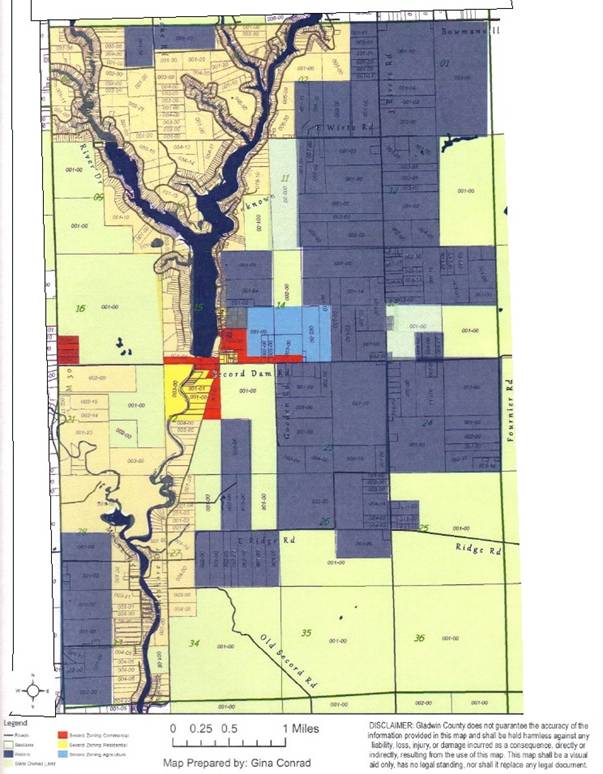
Characteristics Township mapped existing land cover/use in the Township in 2012. The map of existing land use, shown as Figure 5‐1, illustrates the distribution of land uses throughout the Township. Michigan Resource Information System (MIRIS) land cover/use classification categories were used to map the existing land cover/use. The map represents an update of the 1978/1999 MIRIS land cover/use map. The MIRIS map was updated with 2005 digital Ortho‐photos. The updated information was then digitized to produce the existing land cover/use map and statistics. Table 5-1 presents the land uses showing the number of acres and percent of the Township in each of the land use categories.
Figure 5-1.
Existing
Land Use
Map
Forestland (mostly state-owned)
and
shoreline houses dominate
the
landscape
of
Secord Township.
Lowland
forests growing
on
poorly
drained
soils
are
concentrated
in the
eastern
and
southwestern
parts
of
the
Township. These
lowland forests provide important
wildlife cover and
protecting water
quality.
Farming is
sparse with most of the commerce around the Secord Lake in the
central part
of
the community.
Residential
uses are scattered around
the Township,
with the biggest population around the Lake. Commercial
and industrial land
uses are
concentrated
along the
M‐30 and Secord Dam Road
corridor. The majority of the Township
is low‐density
residential development
on both large
and small tracts throughout
the township.
Table 5.1
Secord Township Existing Land Use Statistics: 2012
Agricultural Land Use As
can be
seen in
Table 5-1,
agricultural use
occupies approximately
36.6 percent or (5626
acres) of the
land in the Township.
These
figures include
farmstead residential
as
well
as agricultural development. Majority
of this land use type is in the eastern part of the township on either side of
the Secord Dam Road. These are mostly
parcels more than 2 acres. A small
portion of the southwestern edge along M-30 is also agricultural use.
It is the Plan's intent to discourage
high-density developments in this land use to maintain the rural character and
resort community feel.
Residential
Land Use As
can be
seen in
Table 5-1,
residential use R-1
occupies approximately
6.8 percent (1049
acres) of the
land in the Township.
The R-1 residential is lakefront property on
Secord Lake. The R-2 residential is
non-lakefront property and is in general parcels of 5 to 100 acres.
Single-family
residential parcels account
for essentially all of the
residential development in Secord Township.
These figures
include shoreline residential and subdivisions.
Residential
development
is scattered throughout the Township
but tends to be
concentrated along the Secord
Lake shoreline, the Tittabawassee River and a couple of major roads as shown in
Figure 5-1
Existing Land
Use Map.
The
remaining
is dispersed throughout
the Township. It may be desirable
to service all of this area with public water and sewer systems in the coming
future. Current township zoning
regulations require minimum lot sizes of 12,000 square feet for both
single-family and two-family dwellings.
Commercial Land Use Secord
Township
has limited commercial
development
of general retail and service businesses in the township, primarily to serve the
day-to-day needs of the community year-round. General
uses include small-scale retail, personal service establishments, food services,
marina, and marine repair and storage facilities
occurring primarily along Secord Dam
Road and M-30.
Just over 300
acres, a little under 2 percent
of the
Township's total
land area is developed for
commercial/industrial uses.
The
Township’s closeness to the City of Gladwin precludes it from development of a
big commercial center. Plus the township
does not desire to lose its resort community character by too much traffic or
commerce.
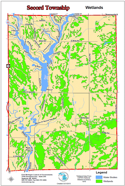
Forests
and
Wetlands The existing
land use map shows these within the
Agriculture and Residential categories.
But, majority of these lands are owned
by the Michigan Department of Natural Resources and Environment (MDNRE).
In
addition
to scenic
characteristics, woodlands
provide habitat
for
wildlife, protect the soil from erosion and
act as a buffer from noise
on heavily traveled
highways. It serves as a
preserved watershed for the wetlands and the other surface waters in the
township. Wetlands
are
defined as land
that has
sufficient water
at,
or
near, the
surface to
support wetland or aquatic
vegetation. These
areas are commonly referred to
as swamps, marshes and bogs.
The
wetland category
comprises
non‐forested types such as lowland brush (tag alder
and willow), sphagnum
bogs, emergent vegetation
in lakes and stream flooding
and wet meadows.
As
can be
noted
on
Figure 5.1 Existing Land
Use Map, the
major wetland
areas are adjacent
to
rivers and the Lake.
The network
of
wetlands receives surface
water and
subsurface water
discharge creating
the many streams
and
creeks that,
in turn, flow
into the
area lakes.
The
interconnected resources
exemplify how
activities distant from
major water
bodies can still
have an
impact on
the water quality.
It
is important
to note
that existing
land
use statistics
used in
this report
are based
on MIRIS data.
Forested
and wetland information contained in the
MIRIS data was not verified by
field inspection
when
the
data was
compiled. Thus,
areas shown
as wetlands
on
the MIRIS system
may
not
actually
meet
State
and
Federal
criteria
for
legally
regulated
wetlands.
However, the
information is still valuable for general land use
planning decisions. The National Wetland Inventory (NWI) maps are more for informational purposes and do not show the exact presence or location of wetlands, nor do they necessarily indicate areas that are regulated by law. These maps were generated mainly through aerial interpretation and serve as a starting point to suggest that wetlands might occur in those areas and likely need further investigation when planning. In order to determine if wetland is actually present on a site, wetland delineation would need to be completed by a wetland professional, usually undertaken by a person proposing the development. The NWI maps will show areas that were historically wetland that are now developed.
Figure 5.2 Secord Wetlands Map In addition, the actual presence of a wetland on a site does not necessarily mean that it is regulated by State law (i.e., requiring a permit from MDEQ to impact). Wetlands must meet certain criteria to be regulated in Michigan under Part 303, Wetlands Protection, of the Natural Resources and Environmental Protection Act, 1994 PA 451, as amended. Furthermore, just because a wetland is regulated does not automatically mean that no construction can occur. A permit application must be submitted prior to construction and will be reviewed by MDEQ staff to determine if it meets criteria in state law and a permit can be issued. Please visit
www.mi.gov/wetlands for
a whole host of information that may answer a lot of your questions regarding
wetland maps, regulations, the permitting process, fees, and where to submit
wetland permit applications.
Surface Water Open
water comprises 576
acres
of
Secord Township, including
Secord Lake and the Tittabawassee River.
| ||||||||||||||||||||||||||||||